All referenced maps are cited at the bottom of the article.
On April 15, 2025, Donald Trump signed Executive Order (EO) 14274, titled “Restoring Common Sense to Federal Office Space Management.” According to the text of it, its purpose is to revoke Jimmy Carter’s EO 12072 and Bill Clinton’s EO 13006 (which I’ll explain further in a moment) and encourage movement of federal facilities to lower-cost areas in the names of efficiency. On paper, I can see the reasoning here. But as an urbanist, I have some questions. I want to break this one down today.
Carter’s EO instructed the federal government to move primary federal government buildings (whether on owned or rented properties) should be relocated to high-density areas for the sake of ease of access to the largest number of people. Clinton reinforced this, with a focus on moving them to the intersection of central business districts and historical districts. And I’m honestly not a huge fan of that latter part of Clinton’s EO, though that’s a deeper investigation for another time. But ultimately, both of their impetuses were to increase access to federal government facilities by putting them where people live.
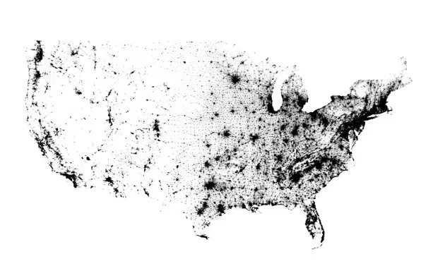
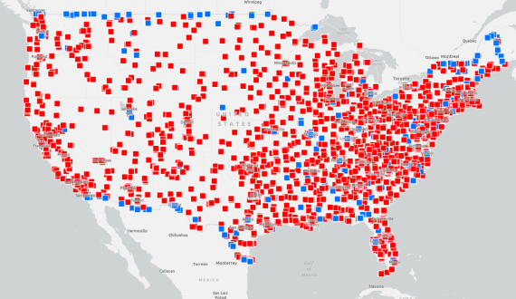
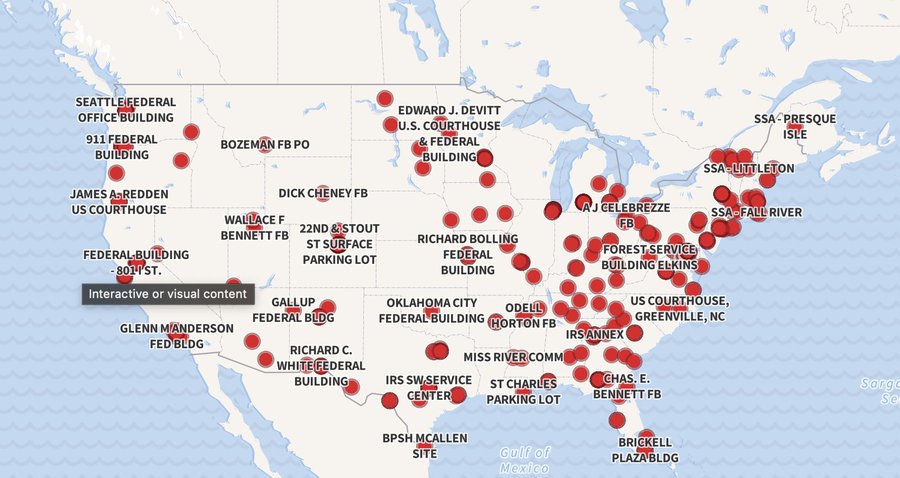
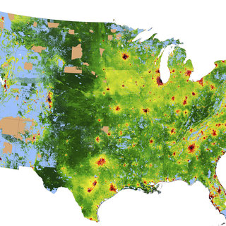
Trump’s EO purports to undo this for cost-efficiency. This is where the maps that I have cited at the bottom come in. The population map easily shows the density of urban areas and relative sparsity of rural areas. And these are backed up by the data – according to the 2020 US Census, 80% of the population in US states lives in an urban area. This map has similar density patterning to the current list of General Service Administration (GSA)-owned properties, the cost of land, and the Department of Government Efficiency’s (DOGE) list of buildings they put up for sale (though this was largely undone after this list was found to include the central offices of multiple government agencies). So yes, the building cost would be higher in urban areas. And more government buildings are situated there. But that’s because 80% of the population lives in these regions, and it was meant to support the most people. It’s not intended to waste money.
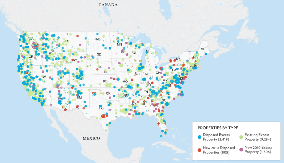
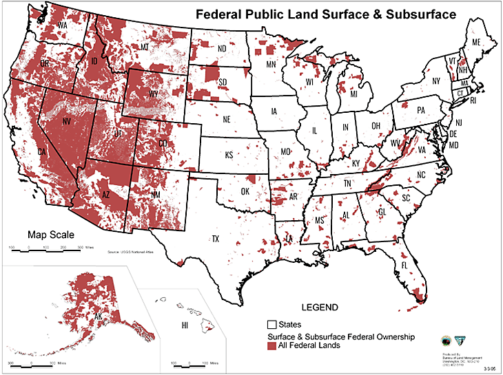
Here’s the thing. Trump isn’t the first president to be concerned that too much money is spent on unused or underused federal properties. In fact, Barack Obama instructed the GSA to study this during his administration. They did find that a large number of properties were considered “excess” – that is, either fully unused or underused to such a significant degree that they provide no long-term benefits of note. There are undeniably some in urban areas, and I would believe this. It makes total sense to me that there would be some that are underutilized regardless of where they are located. But there’s also a large number in distinctly rural areas, where there’s a amount of federally owned land but few people. In my opinion, this shows that it’s not as simple as cost efficiency. There are much more complicated factors that determine what federal lands have value to maintain or sell.
Trump is only looking at one factor – the economic factor. And comparing population maps and lists of GSA buildings to the cost of land, I actually have no doubt that this would save money. But given that again, 80 percent of people live in urban areas, this would cut access to most people and separate them from the federal government. This is an overly simplistic view of what makes a property valuable.
Now, I do actually support one thing about Trump’s EO. I don’t think it’s a bad idea to increase federal support and access to rural areas. I do think that both the Carter and Clinton EO focused so heavily on urban areas that they overlooked the people outside of them. This is, in my opinion, more notable when you consider that the country has continued to urbanize, albeit slowly, since their administrations. According to the US Census Bureau, roughly 73.7 percent of the population lived in urban areas during the Carter administration, while 75.2 percent would have lived there in the Clinton administration. They did overlook large portions of the electorate. That is a real criticism of these policies, and I actually think it makes sense to increase access to rural areas.
However, this shouldn’t come at the expense of the urban areas. If the government is meant to be “by the people, for the people,” then it needs to be where the people are. There are potentially good ideas on the fringes of Trump’s EO. But just redoing federal resources by land prices will disenfranchise the substantial majority of the country.
Population map, c. 2010: A map that provides a dot for every person in the 2010 US Census by Brandon Martin-Anderson
GSA properties, c. 2025: A map of all federal properties owned or managed by the GSA
Excess properties, c. 2011: Analysis of properties deemed “excess” or lacking substantial social, political, economic, educational, or other benefit valuable for the federal government to provide, as published by the GSA
Federal Public Land, c. 2022: A map of all federally own lands, both surface and subsurface, as compiled by Vanessa Brown Calder at the Cato Institute
DOGE sale buildings, c. 2025: Map of buildings that were temporarily on GSA website due to alleged DOGE influences, as compiled by Dhruv Mehrotra, Leah Feiger, Tim Marchman, Zoe Schiffer, and Vittoria Elliott at Wired
Average land price per hectare in the United States, c. 2020: Christoph Nolte at the Proceedings of the National Academies of Sciences